Prologue
On Sunday, 23rd Monday, 24th March 2014, the Malaysian Prime Minister announced that based on the findings of the UK-based Aircraft Accidents Investigations Board it was concluded that the flight of the MH370 ended in the southern Indian Ocean.
This was met by heavy criticism in particular by families and relatives of the passengers who are in Beijing. This is understandable. As humans, we always cling on whatever glimmer of hope there is that our loved ones will somehow appear unscathed. I went through this when my brother passed away three months ago. I kept thinking that this was all a bad dream and that I would wake up to my brother’s jokes, laughter and hugs again. However, such hope should be balanced with situational logic – the acceptance of reality and that should help overcome the pathological grief a person would have. The sooner one accepts reality, the sooner the trauma will heal.
This pathological grief will get prolonged not only if one refuses to accept reality, but also by irresponsible acts to promote hope. Hope is the act of prolonging the arrival of the inevitable. I will here chide the opposition parliamentarians who call upon the government to provide physical proof that the MH370 had indeed crashed. May I just forcefully drag everyone to the reality that the aircraft cannot fly for 19 days; based on the Doppler effect triangulation the last possible location of the aircraft points to the extremely unforgiving southern Indian Ocean. If anyone, just any one person could survive the extremities of the whole situation, then let us just call that a bonus from God. While hope is good to a certain extent, my only hope is for the black boxes to be located before the batteries run out.
The search for debris is not going to be an easy task even on a normal day. Australia’s Prime Minister has described it as “looking for a needle in a haystack, but having to find the haystack first.” I would take that a step farther by saying it is like looking for hundreds of pieces of one single needle in a haystack that has yet to be found. How is that as a perspective? Now add nine-metre waves with lots and lots of whitecaps into the equation.
I take offence at a statement by representatives of the families in Beijing, as well as members of the foreign media, AND the Quislings amongst us here in Malaysia that we (Malaysia and its military) have murdered the passengers and crew, and that we have either been hiding or not been forthcoming with information or both. Malaysia has been providing all information pertaining to this incident on a daily basis, and even to the extent of sharing sensitive military data that has jeopardised its defence just so to render search and rescue efforts more effective. With the information made available to me as well as byAndak Jauhar’s analysis of the MH370 incident I shall draw a timeline so readers would understand why was the SAR conducted in the South China Sea, when exactly was SAR expanded to the west of Peninsular Malaysia, and how fast did information flow in. All times quoted in this timeline is Malaysian time (UTC +8):
08 March 2014
0041 – MH370 took off from the Kuala Lumpur International Airport with 227 passengers and 12 crew members bound for Beijing with an endurance of approximately eight hours.
0107 – the Aircraft Communications Addressing and Reporting System (ACARS) made its last transmission on the aircraft’s performance. All systems were running as per normal. Next transmission was due at 0137 hours.
0119 – a person believed to be the co-pilot acknowledged the handing over of the MH370 from Malaysia’s Flight Information Region (FIR) to Vietnam’s FIR. His last words were, “Alright, goodnight.”
0121 – the secondary radar at Subang’s Air Traffic Control centre lost contact with the MH370 over waypoint IGARI at 06.5515N 103.3443E, after a deliberate act of turning off the transponder as well as other communications equipment. The aircraft was then at 35,000 feet above sea level. However, the aircraft continues to be tracked by the Royal Malaysian Air Force’s (RMAF) primary radar and had its flight path towards waypoint VAMPI monitored and recorded by RMAF’s Air Defence Centres.
0215 – RMAF’s primary radar consistently monitored the path of the MH370 from waypoints VAMPI, GIVAL before finally losing track of it after waypoint IGREX while flying at 29,500 feet above sea level.
As a Contracting State to the ICAO Convention of 1944, Malaysia assumed the role of the Rescue Coordination Centre under Annex 12 of the Convention for the MH370 Search and Rescue efforts because the MH370 had yet to enter Vietnamese FIR control (its radar had not detected the MH370 yet when she changed her flight path). Based on sightings of debris, the Search and Rescue efforts concentrated at its last known position near waypoint IGARI.
0630 – MH370 was to have arrived in Beijing.
0811 – the last handshake between the MH370′s navigation system and an INMARSAT satellite was made.
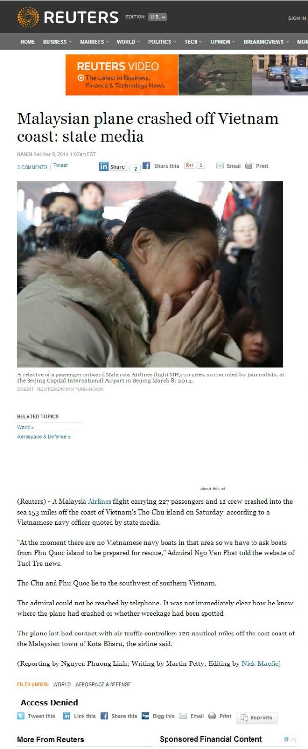
1017 – Rear Admiral Ngo Van Phat of the Vietnamese Navy announced that the MH370 may have crashed about 153 nautical miles (300km) from Tho Chu island, near Ca Mau. This statement was carried by Tuoi Tre News and was subsequently picked up and released by Reuters at 1302 hours, sending SAR assets into the area.
1730 – based on the flight path monitored by the RMAF, the SAR effort was also expanded into the Strait of Malacca.
09 March 2014
- search around Tho Chu island failed to yield anything.
- the SAR efforts were expanded into the Andaman Sea. The RMAF’s sensitive radar data recordings have been shared with the SAR authorities.
10 March 2014
1343 – Vietnamese news agency Tuoi Tre reported that a passing aircraft from Singapore spotted an orange object possibly a liferaft or a lifejacket 177km northwest of Tho Chu island. SAR assets deployed later identified this object as a cable wrap.
11 March 2014
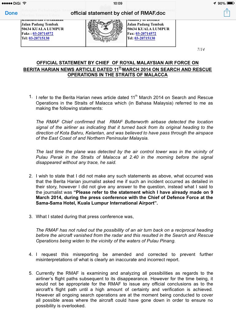
The Malaysian Chief of Air Force issued a press statement refuting a report by the Malaysian dailyBerita Harian that quoted him as supposedly saying the aircraft had flown towards Pulau Perak.
12 March 2014
The official website of the State Administration of Science, Technology, and Industry for National Defence of China (SASTIND) showed pictures of three objects spotted in the South China Sea believed to be related to the MH370. These photos were then shown to the public by the China Central Television (CCTV), Xinhua News Agency, CNN, BBC and also by other foreign news agencies. According to SASTIND, these images were taken at latitude 6.7N 105.65E at 11.00am on 9th March 2014.
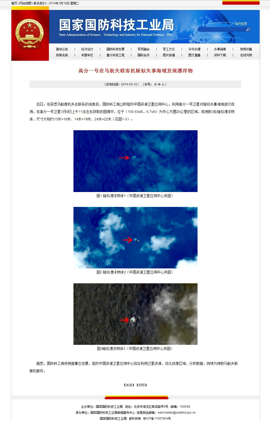
SASTIND website showing debris thought to be related to the MH370
Hence, SAR assets were again sent to verify the findings which we now know were false sightings, but not before more time and concentration of vital resources have been wasted.
14 March 2014
- search was expanded into the Indian Ocean.
15 March 2014
The Malaysian Prime Minister announced that the object tracked by the RMAF’s primary radar was indeed the MH370. This conclusion was made based on processed data acquired from INMARSAT and concurred by the FAA, NSTB, AAIB and the Malaysian authorities.
20 March 2014
The Australian Prime Minister announced satellite images showing large debris in the southern Indian Ocean. The image was taken four days earlier.
22 March 2014
The Chinese government announced that its satellite had found debris in the southern Indian Ocean. That image too was taken four days prior to the announcement.
24 March 2014
The Prime Minister of Malaysia announced that based on triangulation of handshakes between the MH370 and satellites, the flight ended in the southern Indian Ocean.
The rest is academic.
Epilogue
The timeline displayed above shows how Malaysia has, from Day One, been moving as fast as it could to get to the correct pointers only to be side-tracked by false and unverified sightings. Malaysia has also been sharing everything, and literally everything including data of its sensitive military capabilities, as well as air bases so the search and rescue effort would benefit the best out of the information made available to them by the Malaysian authorities.
The timeline above also displays the average time of four days needed for satellite images to be processed before they can be safely suggested to the search and rescue teams.
What the timeline above suggests is that while the authorities are working hard to find the missing aircraft, the families as well as the public in general ought to exercise patience and restraint in their quest to know what happened. The media should be more responsible in reporting the incident as well as the search and rescue efforts as not only will the effects be adversely negative, but irresponsible reporting provides false hopes to the family that are put on an emotional roller-coaster ride on a daily basis.
And to those who call themselves Malaysians but continue in bashing whatever effort the government offers in bringing this episode to a closure, I doubt you qualify even a place as a zoological display for despicable animals.
Shame on you.
[Taken from :seademon.wordpress.com]
No comments:
Post a Comment